Intervisibility analysis method based on DEM raster data

A grid data and analysis method technology, applied in the field of visual analysis, can solve problems such as difficulty in meeting practical application requirements, limiting real-time calculation and analysis efficiency, etc., to reduce the number of file IO operations, reduce the number of I/O operations, and reduce The effect of a small amount of data

Active Publication Date: 2020-09-11
LUDONG UNIVERSITY
View PDF4 Cites 3 Cited by
  • Summary
  • Abstract
  • Description
  • Claims
  • Application Information

AI Technical Summary

Problems solved by technology

In real-time simulation calculation, when it is necessary to calculate the visibility of a specified point to thousands of dynamic target points, more operations are required to read DEM raster data files, which seriously limits the real-time calculation and analysis. efficiency, it is difficult to meet the needs of practical applications

Method used


Image

  • Intervisibility analysis method based on DEM raster data
  • Intervisibility analysis method based on DEM raster data
  • Intervisibility analysis method based on DEM raster data

Examples


Embodiment Construction

[0054] The following is attached Figure 1-4 The principles and features of the present invention are described, and the examples given are only used to explain the present invention, and are not used to limit the scope of the present invention.

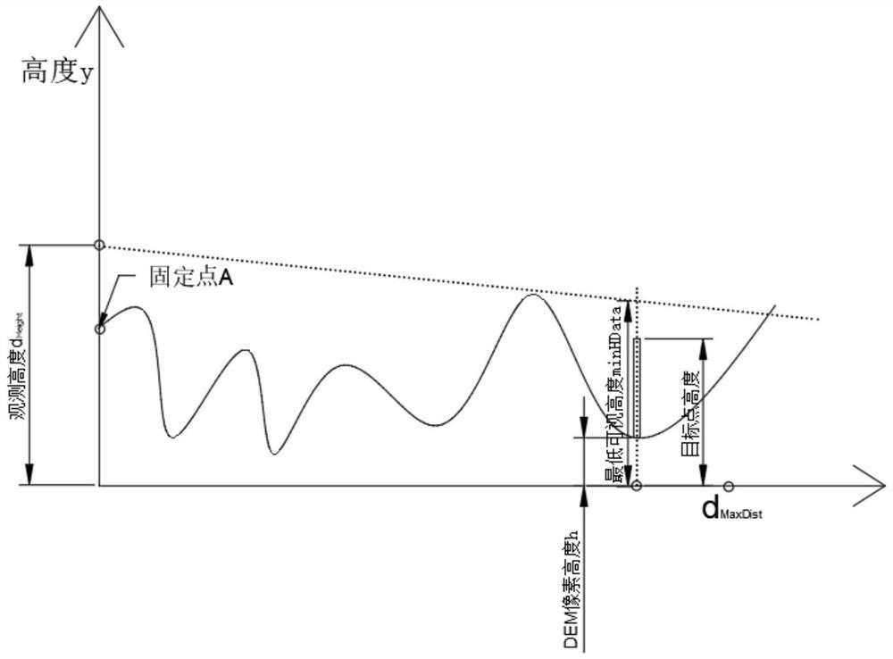
[0055] Assume that the longitude of the given observation point A is d Lon , latitude d Lat (unit: degree), the observation height is d Height rice. Suppose the maximum line-of-sight distance of the observation point is d MaxDist m, in order to be able to perform line-of-sight analysis and calculation on any target point around the observation point, it is necessary to collect DEM raster data. The DEM raster data is a typical raster data, consisting of M rows and N columns of DEM raster pixels, and the width (equal to its height) of each DEM raster pixel is d Resolution m, in the case of the minimum amount of data, the DEM raster data to be collected is the center point of the observation point, with 2*d MaxDist It is the raste...


PUM


Abstract

The invention discloses an intervisibility analysis method based on DEM raster data. The intervisibility condition of the observation point between any points within the maximum intervisibility distance is analyzed in real time by using the summary height data; the method comprises the following steps: firstly, calculating the minimum height required by the visibility between the position where DEM grid pixels are located and an observation point offline; obtaining minimum visual height raster data, dividing the minimum visual height raster data into a plurality of pieces of block data, performing statistics on summary information of each piece of block data to obtain summary height data, the summary information of the block data comprising a maximum pixel value in a block and a minimum pixel value in the block; then performing intervisibility analysis based on summary information of the block data; therefore, only summary height data with very small data volume need to be called intothe memory during intervisibility analysis, so that original data required by real-time calculation is greatly reduced, multiple file IO operations are avoided, the intervisibility analysis efficiencyis remarkably improved, and meanwhile, the calculation accuracy is also ensured. The invention further discloses another intervisibility analysis method.

Description

technical field [0001] The invention relates to the field of visual analysis, in particular to a visual analysis method based on DEM grid data. Background technique [0002] Visibility analysis refers to the topographic analysis of studying the visibility of a certain area with a certain point as the observation point. The technical method of using DEM to judge whether any two points on the terrain can be seen from each other can be divided into line-of-sight analysis and visual domain analysis. The former judges whether any two points can be seen, and the latter starts from a certain point. Judge the visibility of all other points in the area. [0003] Line-of-sight analysis essentially belongs to the category of terrain optimization, such as setting up radar stations, TV stations, navigation and navigation, etc., and in the military, such as setting up positions, setting up observation posts, and real-time simulation systems. [0004] The establishment of the digital ele...

Claims


Application Information

Patent Timeline
IPC IPC(8): G06T17/05
CPCG06T17/05Y02A90/10
Inventor 闫富松周聪俐
Owner LUDONG UNIVERSITY
Why Eureka
Try Eureka