Drawing method of Chinese and English intercontinental land-sea geomorphologic map

A Chinese and English, geomorphological technology, applied in the directions of maps/plans/charts, instruments, educational appliances, etc., can solve the problems of small amount of information, lengthy text description, large amount of legend classification and so on

Active Publication Date: 2013-01-09
南京市测绘勘察研究院股份有限公司
View PDF1 Cites 0 Cited by
  • Summary
  • Abstract
  • Description
  • Claims
  • Application Information

AI Technical Summary

Benefits of technology

This patented technology describes an improved way for compiling data from seismicity analysis (SE) plots into geometrical models called lands or lines. These techniques help scientists analyze complex datasets quickly without having to manually sort them downwardly over multiple pages. They use this technique to make it easier than previous ways to interpret SE data. Overall, these improvements improve efficiency and accuracy in analyzing geophysically relevant phenomena such as sedimentation dynamics and fault movement.

Problems solved by technology

Geologically speaking, traditional techniques for analyzing and representing spatial relationships between objects such as space occupancy (geograph) data involve categorizing them manually through their appearance characteristics like shape, texture, location, etc., but this process requires significant effort from human operators who often overlook important aspects related to these attributes. There may exist issues where ambiguity arises due to lack of knowledge about how certain parts relate together within the mapped area.

Method used


Image

  • Drawing method of Chinese and English intercontinental land-sea geomorphologic map
  • Drawing method of Chinese and English intercontinental land-sea geomorphologic map
  • Drawing method of Chinese and English intercontinental land-sea geomorphologic map

Examples


Embodiment Construction

[0055] Below in conjunction with specific embodiment, further illustrate the present invention, should be understood that these embodiments are only used to illustrate the present invention and are not intended to limit the scope of the present invention, after having read the present invention, those skilled in the art will understand various equivalent forms of the present invention All modifications fall within the scope defined by the appended claims of the present application.

[0056] Below with " whole map of land and sea geomorphology of Asia and adjacent area (1: 8 million) " as specific example, specifically introduce the concrete steps of the mapping method of Chinese-English intercontinental land and sea geomorphology map of the present invention (such as figure 1 shown).

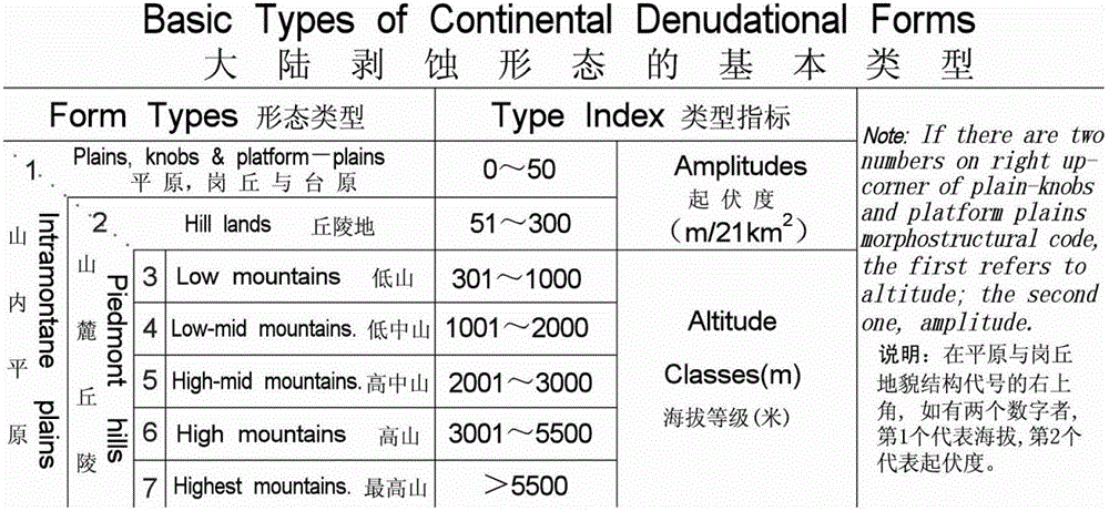
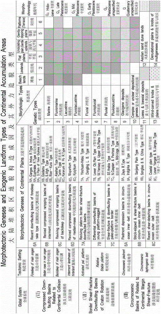
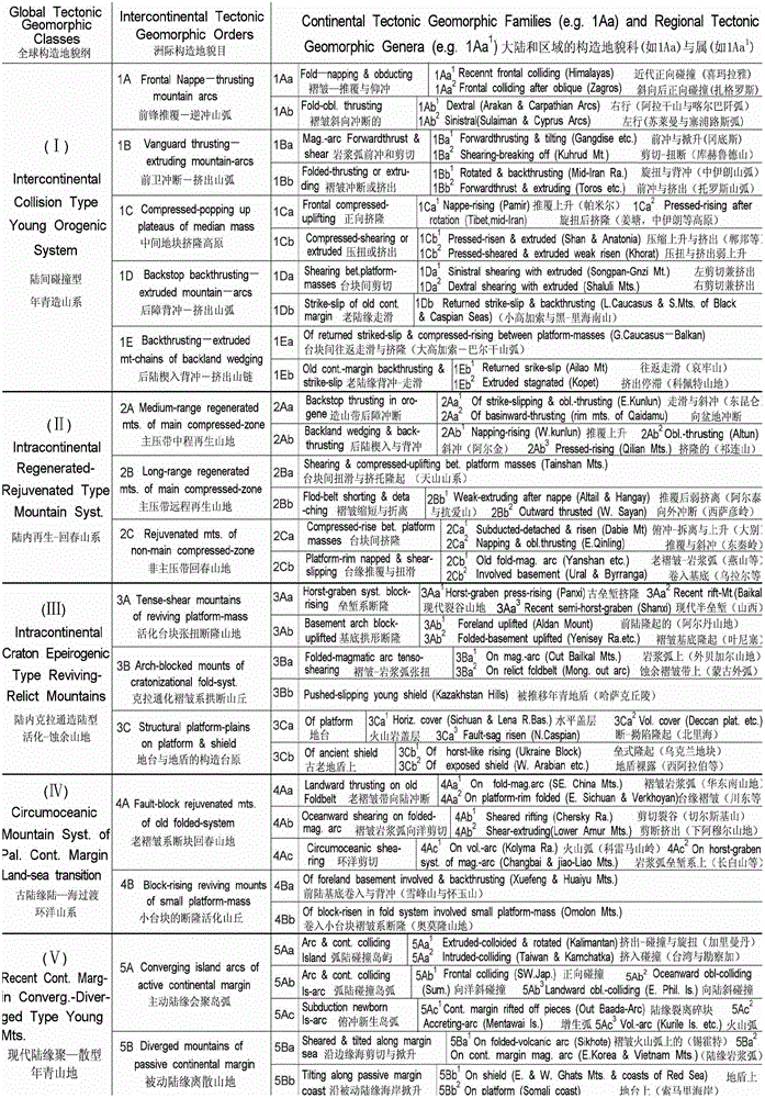
[0057] Step 1. Determine the classification system of the land and sea geomorphology map of Asia - the grade and level division of digital geomorphology

[0058] Under the guidance of the overall


PUM


Abstract

The invention discloses a drawing method of a Chinese and English intercontinental land-sea geomorphologic map. The cartographic method comprises the following steps of firstly, confirming a classification system of the land-sea geomorphologic map according to the plate tectonics; then integrating multi-source data to form a data production scheme, and forming a error correction scheme by adopting a graticule as a control network and longitude and latitude intersecting points as error control points; secondly, confirming a plane layer structure, a layer coordination scheme, a legend system and a representation of the geomorphologic map; finally confirming the arrangement mode of Chinese and English notes by adopting the graticule as the basic of the arrangement of the Chinese and English notes, and carrying out interpolation of latitude lines in a mapland by the latitude difference of 1 DEG by adopting the graticule as the basic control network. According to the cartographic method disclosed by the invention, the topogrphy classification is carried out on the basis of the plate tectonics, English comparison of plate tectonic landform new terms is adopted, and in the process of compiling the Asian geomorphologic map by a computer, the principle of classification of the plate tectonic landform is reflected and the geomorphic feature of the mapland is expressed, so that the representation of the geomorphologic map is readable and visualized.

Description


Claims


Application Information

Patent Timeline
Owner 南京市测绘勘察研究院股份有限公司
Why Eureka
Try Eureka