Vector geospatial data digital watermarking method based on angle difference
A vector geographic and spatial data technology, applied in image data processing, image data processing, instruments, etc., can solve problems affecting the invisibility of watermarks, reducing the practicability of watermarking algorithms, and limited data deformation
- Summary
- Abstract
- Description
- Claims
- Application Information
AI Technical Summary
Problems solved by technology
Method used
Image

Examples
Embodiment Construction
[0065] The present invention will be further described below in conjunction with the accompanying drawings and embodiments.
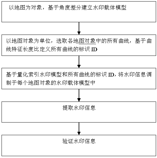
[0066] Such as figure 1 As shown, a digital watermarking method for vector geospatial data based on angle difference includes the following steps:
[0067] 1) Taking the map as the object, the watermark carrier model is established based on the angle difference. The specific steps are:
[0068] 1-1) Extract feature point set: Select all the curves in the map object, and for each curve, extract the curve feature points in the curve, and use the angle formed by the curve feature points as the feature domain of the embedded watermark; the curve feature point extraction adopts Douglas -Pook's algorithm.
[0069] The extraction process of curve feature points is as follows:
[0070] (a) A curve Q in the selected map object 1 , the curve Q 1 The first and last nodes are used as the initial feature points, and are recorded as P 1 ,P n , at P 1 ,P n Conn
PUM
 Abstract
Description
Claims
Application Information
 - R&D Engineer
- R&D Manager
- IP Professional
- Industry Leading Data Capabilities
- Powerful AI technology
- Patent DNA Extraction
Browse by: Latest US Patents, China's latest patents, Technical Efficacy Thesaurus, Application Domain, Technology Topic.
© 2024 PatSnap. All rights reserved.Legal|Privacy policy|Modern Slavery Act Transparency Statement|Sitemap