A task scheduling method based on prospective prediction
A task scheduling and task technology, applied in the direction of instruments, data processing applications, resources, etc., can solve the problem of the sharp increase of satellite storage capacity, and achieve the effect of improving utilization and reducing storage capacity.
- Summary
- Abstract
- Description
- Claims
- Application Information
AI Technical Summary
Problems solved by technology
Method used
Image

Examples
Example Embodiment
[0026] Example 1
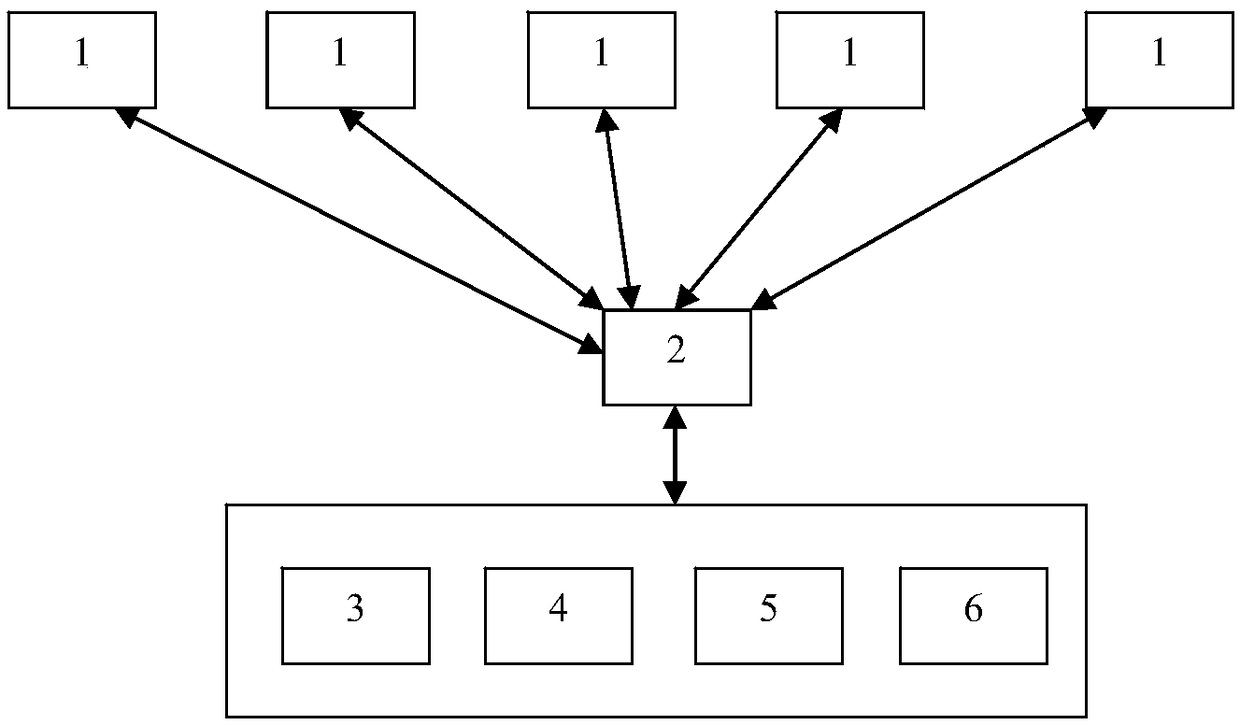
[0027] Such as figure 1 As shown, the present invention discloses a task scheduling system and method based on forward prediction, which at least includes a remote sensing satellite 1 and a ground station 2 communicating with each other. The remote sensing satellites can be several satellites distributed on different orbits for performing image acquisition tasks. The ground station is used to establish data communication with the remote sensing satellite, so that the control command of the ground station can be transmitted to the remote sensing satellite when the remote sensing satellite enters the communication coverage area of the ground station, and at the same time, the image data collected by the remote sensing satellite can also be downloaded at this time To the ground station. The number of ground stations can be flexibly set according to actual usage requirements. For example, when the number of remote sensing satellites is increased in order to obtain
Example Embodiment
[0043] Example 2
[0044] This embodiment is a further improvement of Embodiment 1, and the repeated content will not be repeated.
[0045] Preferably, the task scheduling module also completes the remote sensing satellite scheduling by establishing a scheduling instruction at least according to the following steps:
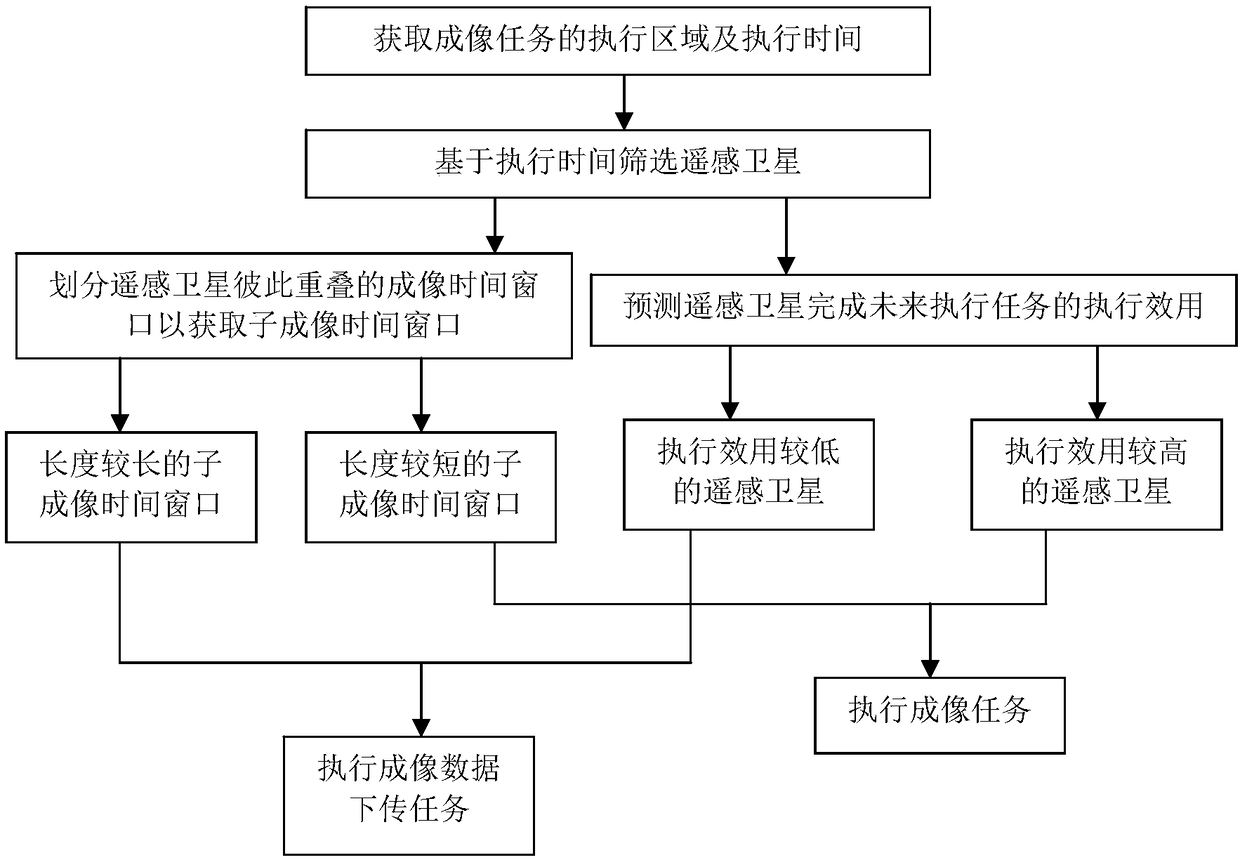
[0046] S1: Preliminarily classify imaging tasks based on the associated execution area information, imaging satellites, and imaging window time to establish an imaging task set that requires at least two remote sensing satellites 1 to complete cooperatively.
[0047] Preferably, the central processing module 6 is also configured to preliminarily classify the corresponding imaging tasks based on the real-time task demand data of the third party. Imaging tasks can be classified into the first type, the second type and the third type. The imaging tasks belonging to the first type are those that cannot be completed without proper satellite resources or due to other constraints,
Example Embodiment
[0058] Example 3
[0059] This embodiment is a further improvement of the foregoing embodiment, and the repeated content will not be repeated.
[0060] Preferably, the task scheduling module also completes the remote sensing satellite scheduling by establishing a scheduling instruction at least according to the following steps:
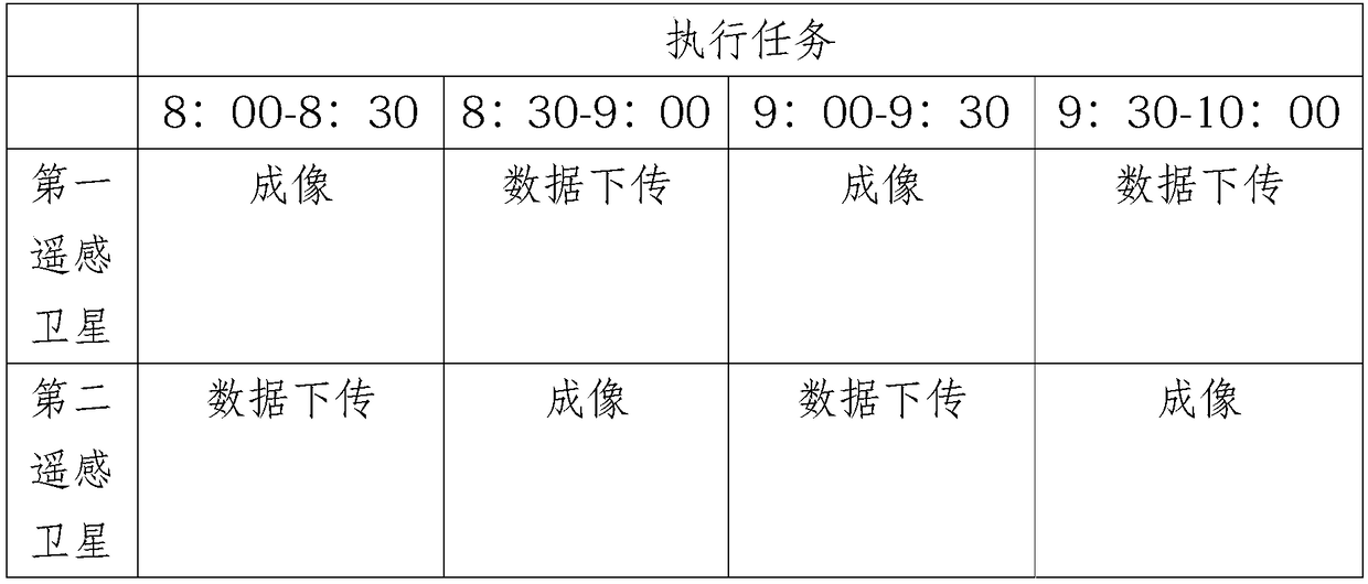
[0061] S1: Obtain the start execution time and the end execution time of the imaging task that requires at least two remote sensing satellites 1 to complete cooperatively, and filter out at least one first remote sensing satellite and at least one first remote sensing satellite whose imaging time window contains the start execution time and the end execution time respectively Two remote sensing satellites, if the combination of the imaging time windows of the first remote sensing satellite and the second remote sensing satellite cannot fully cover the execution time of the imaging mission, at least one third remote sensing satellite is selected.
[0062] Prefera
PUM
 Abstract
Description
Claims
Application Information
 - R&D Engineer
- R&D Manager
- IP Professional
- Industry Leading Data Capabilities
- Powerful AI technology
- Patent DNA Extraction
Browse by: Latest US Patents, China's latest patents, Technical Efficacy Thesaurus, Application Domain, Technology Topic.
© 2024 PatSnap. All rights reserved.Legal|Privacy policy|Modern Slavery Act Transparency Statement|Sitemap