Real-time positioning method and system for target critical point of unmanned aerial vehicle and storage medium

A technology of real-time positioning and drones, applied in closed-circuit television systems, computer components, instruments, etc., can solve the problems of huge resource consumption, complex background, low false alarm rate, etc., to ensure the safety of life and property, and the algorithm is simple , the effect of low false alarm rate

Active Publication Date: 2019-04-26
WUHAN INSTITUTE OF TECHNOLOGY
View PDF8 Cites 0 Cited by
  • Summary
  • Abstract
  • Description
  • Claims
  • Application Information

AI Technical Summary

Benefits of technology

This patented technique helps identify specific areas within an entire picture (image) captured from different angles). It uses images obtained during flight to estimate its location and orientation. By doing this, precise tracking becomes possible even when there may have many objects near one another. Additionally, the use of advanced algorithms makes calculations faster than traditional methods like radon transform analysis while also improving efficiency compared to previous techniques such as binary search. Overall, these technical features improve situational awareness capabilities for drones, particularly those equipped with cameras.

Problems solved by technology

This patented technical problem addressed in this patents relates to finding ways to prevent or reduce unauthorized access (UAA) attacks that may be caused through multiple rotors dronies flying over an area without permission from governments or soldiers. Current methods involve searching for specific areas where there might be potential attack points beforehand but they require expensive equipment like radars and cameras.

Method used


Image

  • Real-time positioning method and system for target critical point of unmanned aerial vehicle and storage medium
  • Real-time positioning method and system for target critical point of unmanned aerial vehicle and storage medium
  • Real-time positioning method and system for target critical point of unmanned aerial vehicle and storage medium

Examples


Embodiment 1

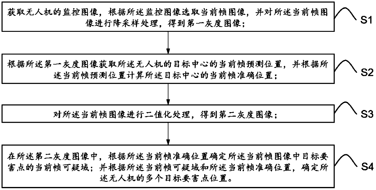
[0080] Embodiment one, as figure 1 As shown, a method for real-time positioning of UAV target key points, comprising the following steps:

[0081] S1: Obtain the monitoring image of the drone, select a current frame image from the monitoring image, and perform down-sampling processing on the current frame image to obtain a first grayscale image;

[0082] S2: Obtain the current frame predicted position of the target center of the drone according to the first grayscale image, and calculate the current frame accurate position of the target center according to the current frame predicted position;

[0083] S3: Perform binarization processing on the current frame image to obtain a second grayscale image;

[0084] S4: In the second gray-scale image, determine the current frame suspicious area of ​​the target key point in the current frame image according to the accurate position of the current frame; and determine the current frame suspicious area and the current frame accurate positi

Embodiment 2

[0143] Embodiment two, such as Figure 9 As shown, this embodiment is a schematic structural diagram of a real-time positioning system for UAV target key points.

[0144] A real-time positioning system for key points of an unmanned aerial vehicle, comprising a monitoring unit 11, a down-sampling processing unit 12, a computing unit 13, a binarization processing unit 14, and a search unit 15;

[0145] The monitoring unit 11 is used to obtain the monitoring image of the unmanned aerial vehicle;

[0146] The down-sampling processing unit 12 is configured to select a current frame image according to the monitoring image, and perform down-sampling processing on the current frame image to obtain a first grayscale image;

[0147] The computing unit 13 is used to obtain the current frame predicted position of the target center of the drone according to the first grayscale image, and calculate the current frame accurate position of the target center according to the current frame predict

Embodiment 3

[0152] Embodiment 3, based on Embodiment 1 and Embodiment 2, the present invention also discloses a real-time positioning system for key points of UAV targets, such as Figure 10 as shown, Figure 10 It is a schematic structural diagram of another real-time positioning system for UAV target key points in the present invention, including a processor 100, a memory 200, and a computer program 300 stored in the memory 200 and operable on the processor 100. The computer program 300 implements the following specific steps when running:

[0153] S1: Obtain a monitoring image of the drone, select a current frame image according to the monitoring image, and perform down-sampling processing on the current frame image to obtain a first grayscale image;

[0154] S2: Obtain the current frame predicted position of the target center of the drone according to the first grayscale image, and calculate the current frame accurate position of the target center according to the current frame predicte


PUM


Abstract

The invention relates to an unmanned aerial vehicle target main point real-time positioning method and system and a storage medium, and the method comprises the steps: obtaining a monitoring image ofan unmanned aerial vehicle, selecting a current frame image according to the monitoring image, and carrying out the downsampling of the current frame image, and obtaining a first gray level image; Obtaining a current frame prediction position of the target center according to the first grayscale image, and calculating a current frame accurate position of the target center according to the currentframe prediction position; Performing binarization processing on the current frame image to obtain a second gray level image; In the second gray level image, determining a current frame suspicious area of a target main point in the current frame image according to the accurate position of the current frame; And determining the positions of a plurality of target critical points of the unmanned aerial vehicle according to the current frame suspicious area and the current frame accurate position. The method can quickly and accurately position the essential points of the unmanned aerial vehicle inreal time, meets the requirements of multi-rotor high-frame-frequency processing and complex background recognition, and can be widely applied to the technical field of unmanned aerial vehicle countering.

Description


Claims


Application Information

Patent Timeline
Owner WUHAN INSTITUTE OF TECHNOLOGY
Why Eureka
Try Eureka