Mineral searching calibration method and system for element geochemical data screening

A geochemical and data screening technology, applied in the field of minerals, can solve the problems of reducing the accuracy and accuracy errors of research measurement results, and achieve the effects of small errors, avoiding data mutations, and reducing the impact of data

Pending Publication Date: 2021-06-15
LIAONING TECHNICAL UNIVERSITY
View PDF0 Cites 2 Cited by
  • Summary
  • Abstract
  • Description
  • Claims
  • Application Information

AI Technical Summary

Benefits of technology

This patented technology helps gather accurate measurements from various terrains by grouping these elements together based upon their spatial location within those terraces. It uses both methods like geodesic matching or reverse time weighting averaging to combine all available survey results accurately without any significant changes over space. Additionally, this process involves selecting appropriate parameter values for analysis and adjustment, resulting in less impact on the quality of the final result compared to traditional approaches such as grid search techniques.

Problems solved by technology

This patented technical solution discusses the use of miners (mineral resource) from natural sources like sedimentary rock deposits around the globe during exploitation activities due to its potential benefits over fossil fuel production. These minerancies can be categorized into three main types - lithium hydroxide (LiOH), sodium sulfate (NaS2), calcium carbonates (CaCOs). They include both LiH+ ion and Na + cations, along with many others found within these materials. Overall, this patents provides examples showing the importance of studying mineral distributions accurately across multiple regions while minimizing variations caused by factors related to the location where it occurs.

Method used


Image

  • Mineral searching calibration method and system for element geochemical data screening
  • Mineral searching calibration method and system for element geochemical data screening
  • Mineral searching calibration method and system for element geochemical data screening

Examples


Embodiment 1

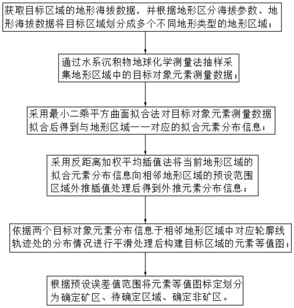
[0057] Embodiment 1: A method for ore-seeking calibration of elemental geochemical data screening, such as figure 1 As shown, it is specifically implemented by the following steps.

[0058] S101: Acquire the terrain altitude data of the target area, and divide the target area into multiple terrain areas of different terrain types according to the terrain altitude parameters and terrain altitude data; in this embodiment, the terrain types include mountains, plateaus, basins, and hills and plain.

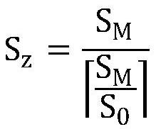
[0059] The topographic area includes at least one independent topographic sub-area, and each topographic sub-area includes at least one collection area. The area calculation formula of the collection area is:

[0060]

[0061] Among them, S z Indicates the size of the collection area, S M Indicates the area size of the terrain sub-region, S 0 Indicates the preset area size, means S M with S 0 The ratio of is rounded up. It should be noted that if the terrain area is surrounde

Embodiment 2

[0072] Embodiment 2: An ore-seeking calibration system for elemental geochemical data screening, comprising:

[0073] The area division module is used to obtain the terrain elevation data of the target area, and divide the target area into a plurality of terrain areas with different terrain types according to the terrain altitude parameters and the terrain altitude data;

[0074] The data acquisition module is used to sample and collect elemental measurement data of target objects in the topographical area through the geochemical measurement method of water system sediments;

[0075] The data fitting module is used to obtain fitting element distribution information one-to-one corresponding to the terrain area after fitting the element measurement data of the target object by using the least squares square surface fitting method;

[0076] The data extrapolation module is used to use the inverse distance weighted average interpolation method to extrapolate and interpolate the fitte


PUM


Abstract

The invention discloses a mineral searching calibration method and system for element geochemical data screening, and relates to the technical field of mineral products, and the method is characterized by comprising: dividing a target area into a plurality of terrain areas of different terrain types; sampling and collecting target object element measurement data in the terrain area; fitting the target object element measurement data to obtain fitting element distribution information in one-to-one correspondence with the topographic areas; carrying out extrapolation interpolation processing on the fitting element distribution information of the current terrain area to a preset range area of the adjacent terrain area to obtain extrapolation element distribution information; carrying out smoothing processing according to the distribution condition of the element distribution information of the two target objects at the corresponding contour line tracks in the adjacent topographic regions, and then constructing an element contour diagram of the target region; and dividing the element equivalent value into a determined mining area, a to-be-determined area and a determined non-mining area. According to the method and system, calibration information with small errors and high accuracy can be obtained, and data support is provided for further research on mineral distribution.

Description


Claims


Application Information

Patent Timeline
Owner LIAONING TECHNICAL UNIVERSITY
Why Eureka
Try Eureka