Static load test remote geographic position acquisition and monitoring system

A geographical location and static load test technology, applied in the field of information collection, can solve the problems that the location cannot be effectively monitored and affects the promotion and application, and achieve the effect of high-precision geographic location collection, authenticity, and real-time supervision

Pending Publication Date: 2020-12-01
广东省建设工程质量安全检测总站有限公司
View PDF11 Cites 0 Cited by
  • Summary
  • Abstract
  • Description
  • Claims
  • Application Information

AI Technical Summary

Benefits of technology

The technical effect of this patented system is that it allows for precise tracking over large areas with accurate data without having human interference or requiring expensive equipment like GPS devices. This helps gather important details about locations such as roads, buildings, tunnels, etc., which can be used by authorities during construction projects to improve safety measures and prevent accidents caused by improperly constructed structures.

Problems solved by technology

This patents discusses various technical issues related to ensuring accurate and reliable ground tests during building constructions such as those involving large numbers of small concrete columns that require more precise measurements than what was previously possible due to limitations associated with current laboratory techniques like manual loading and recording. Additionally, these challenged new technologies from both civil engineering fields (geology) and industrial applications (building materials).

Method used


Image

  • Static load test remote geographic position acquisition and monitoring system

Examples


Embodiment Construction

[0019] Below, in conjunction with accompanying drawing and specific embodiment, the present invention is described further:

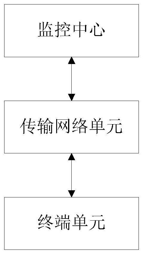
[0020] Such as figure 1 As shown, the present invention provides a static load test remote geographic location acquisition and monitoring system, including a monitoring center, a transmission network unit and a terminal unit, the monitoring center is connected to the terminal unit through the transmission network unit, and the monitoring center includes an electronic map management module The terminal unit is used to obtain the geographic location information of the detected object in real time, and transmit it to the monitoring center through the transmission network unit, so that the electronic map management module in the monitoring center displays the geographic location information of the detected object in real time.

[0021] The present invention displays the position of the detection object on the electronic map management module by receiving the d


PUM


Abstract

The invention discloses a static load test remote geographic position acquisition and monitoring system. The system comprises a monitoring center, a transmission network unit and a terminal unit; themonitoring center is connected with the terminal unit through the transmission network unit; the monitoring center comprises an electronic map management module; the terminal unit is used for acquiring geographical location information of a detected object in real time and transmitting the geographical location information to the monitoring center through the transmission network unit, so that theelectronic map management module in the monitoring center displays the geographical location of the detected object in real time. According to the system of the invention, a geographic position acquisition and monitoring mode is set, high-precision geographic position acquisition is realized, acquired geographic position information is automatically uploaded to the monitoring center in real time,remote real-time acquisition and monitoring of the geographic position information of static load test projects and detection objects are finally realized, real-time supervision of the positions of the detection objects is ensured, and thus authenticity of detection is ensured.

Description


Claims


Application Information

Patent Timeline
Owner 广东省建设工程质量安全检测总站有限公司
Why Eureka
Try Eureka