Remote sensing method for quantifying the grazing intensity of alpine meadow

A meadow and alpine technology, which is applied in the field of remote sensing to quantify the grazing intensity of alpine meadows, can solve the problems of inability to accurately quantify the grazing intensity of large-scale grasslands, and achieve the effect of accurate quantification

Pending Publication Date: 2021-06-04
XINJIANG AGRI UNIV
View PDF1 Cites 0 Cited by
  • Summary
  • Abstract
  • Description
  • Claims
  • Application Information

AI Technical Summary

Problems solved by technology

[0003] The purpose of the present invention is to provide a remote sensing method for quantifying the grazing intensity of alpine mead

Method used


Image

  • Remote sensing method for quantifying the grazing intensity of alpine meadow
  • Remote sensing method for quantifying the grazing intensity of alpine meadow

Examples


Embodiment Construction

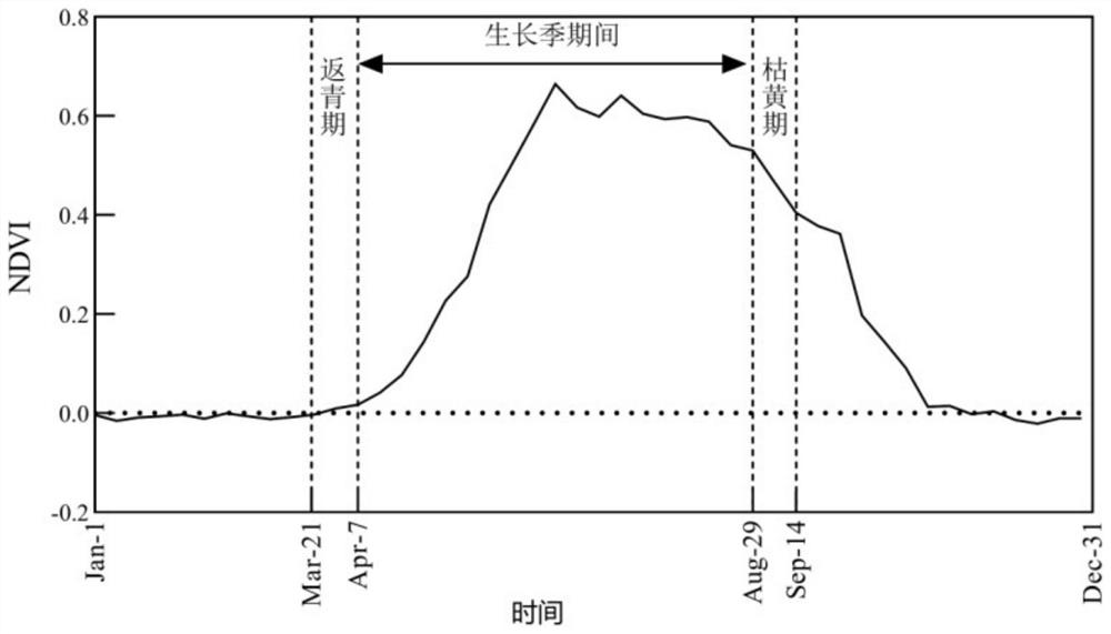
[0022] The specific implementation method of the present invention will be further described below through an application case of quantifying the grazing intensity of alpine meadow.

[0023] Implementation of a remote sensing method to quantify grazing intensity in alpine meadows proceeds as follows:

[0024] Step 1. Obtain the MOD13Q1 data of the study year in the study area

[0025] Download MODIS terrestrial product MOD13Q1 data in the study area in 2011, use MRT (MODIS ReprojectionTool) software to convert MOD13Q1 data format and map projection, convert HDF format to TIFF format, and convert sinusoidal map projection to GCS_WGS_1984 map projection;

[0026] Step 2. Extract the grassland coverage map of the study year in the study area

[0027] According to the above step 1, the transformed MOD13Q1 data was cut using the clipping function of ArcGIS software to cut the alpine meadow distribution vector map and the Tiff image map of MODIS13Q1, and extract the alpine meadow gras


PUM


Abstract

The invention relates to a method for measuring grazing intensity, in particular to a remote sensing method for quantifying the grazing intensity of alpine meadow, which comprises the following steps of: acquiring MOD13Q1 data of a research year of a research area; extracting a grassland coverage map of the research region in the research year; obtaining all MOD13Q1 data in the vegetation growth season time period of the research area; extracting a vegetation index NDVI (normalized difference vegetation index) graph in a vegetation growth season time period of the research area; calculating the accumulated NDVI index in the growth season time period of the research area; calculating the change frequency of the NDVI in the growth season time period of the research area; dividing the grazing intensity of the research time period of the research area. According to the method, the grassland grazing intensity in the large area range is quantified by utilizing a remote sensing method, the limitation of qualitative research on the grassland grazing intensity in traditional field investigation is overcome, and rapid, efficient and accurate quantification of the grassland grazing intensity in the large area range based on satellite remote sensing data is realized; and the time, the place and the degree of grassland grazing intensity in the research area are quantitatively given.

Description


Claims


Application Information

Patent Timeline
Owner XINJIANG AGRI UNIV
Why Eureka
Try Eureka