Longitude and latitude information update method and device in LTE system

A technology of longitude, latitude and longitude, which is applied in the field of satellite positioning, and can solve problems such as inability to accurately determine visible satellite ephemeris information, poor coarse positioning accuracy of the A-GNSS platform, and inability to obtain cell location information, etc.

Active Publication Date: 2017-04-05
CHINA ACADEMY OF INFORMATION & COMM
View PDF4 Cites 0 Cited by
  • Summary
  • Abstract
  • Description
  • Claims
  • Application Information

AI Technical Summary

Problems solved by technology

For non-operators, since the precise cell location information cannot be obtained, it is impossible to accurately determine the ephemeris information of visible satellites as GNSS auxiliary information for terminal positioning
Therefore, the A-GNSS platform deployed by non-operators may have problems such as poor coarse positioning accuracy and long positioning time, which cannot meet the needs of users

Method used


Image

  • Longitude and latitude information update method and device in LTE system
  • Longitude and latitude information update method and device in LTE system
  • Longitude and latitude information update method and device in LTE system

Examples


Embodiment 1

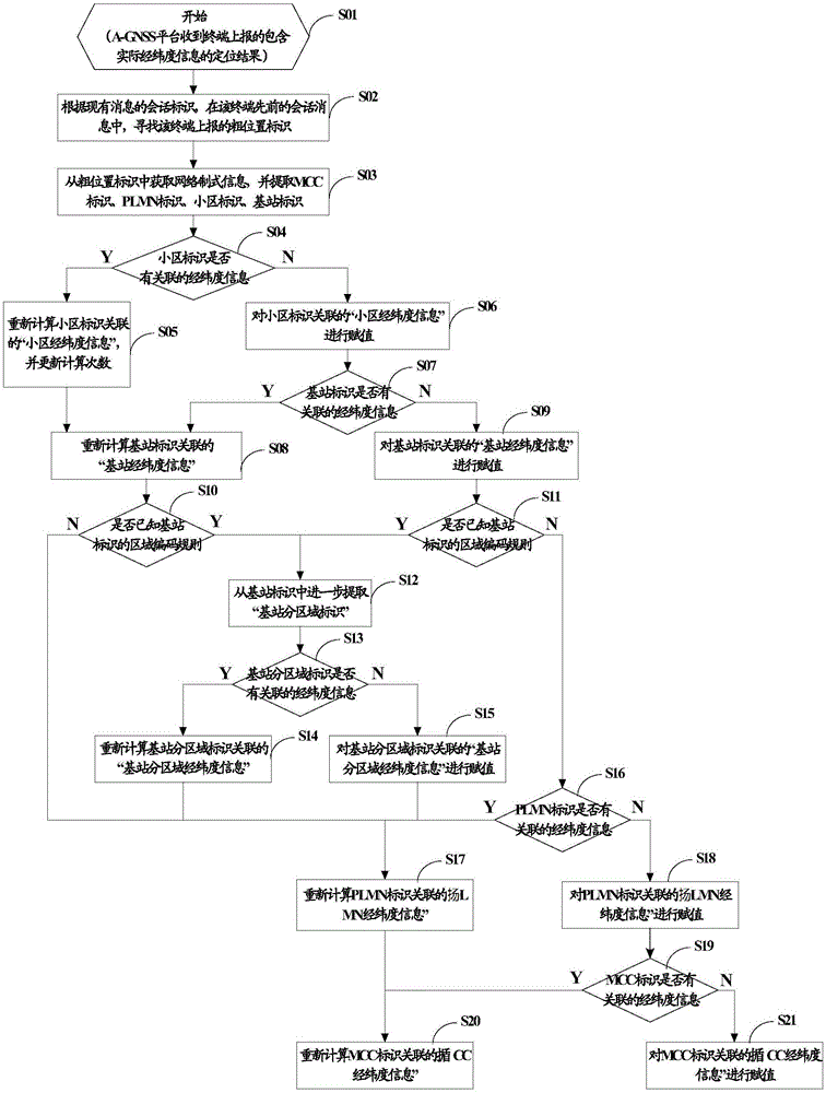
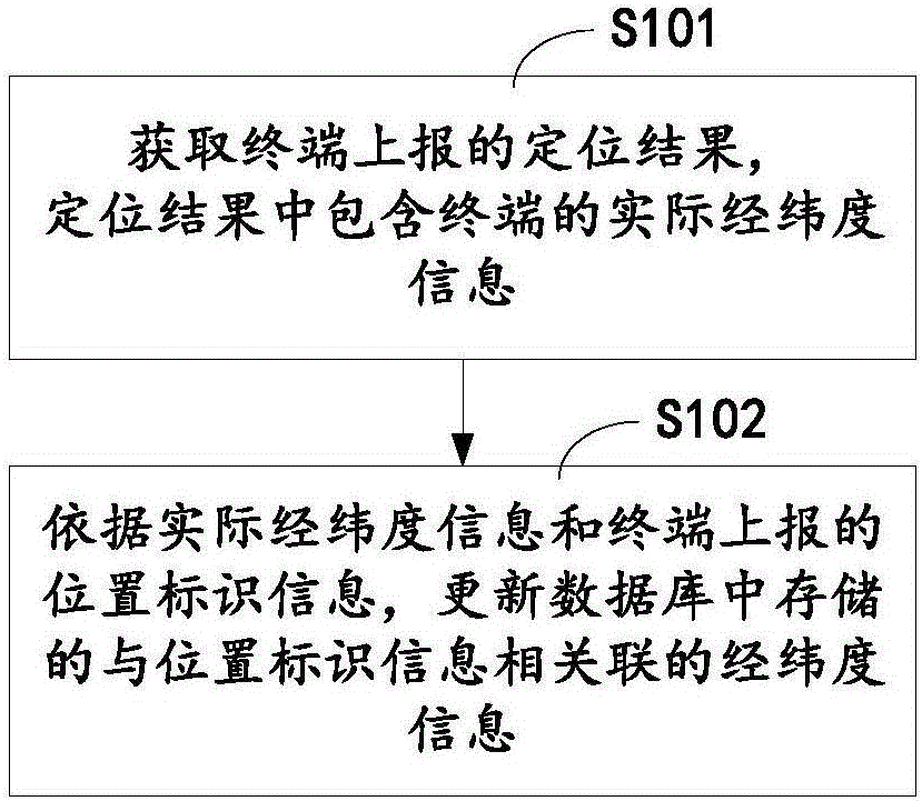
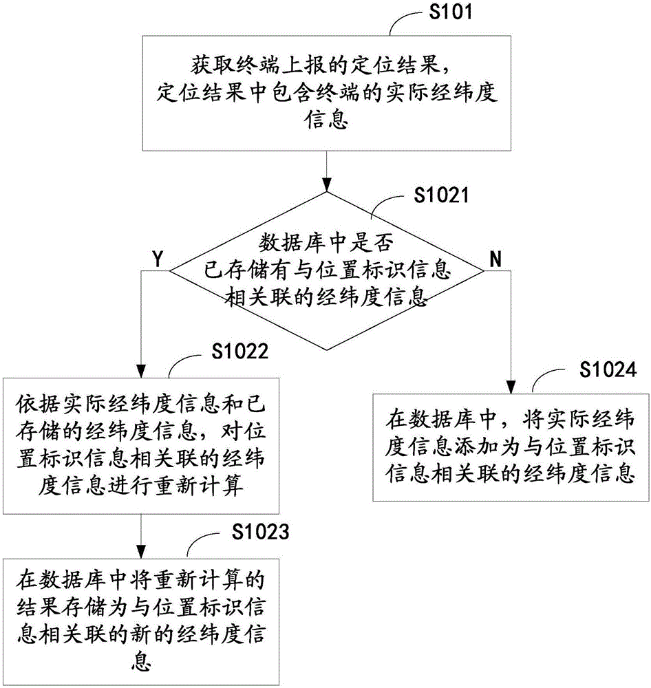
[0085] figure 1 A schematic flow diagram of a method for updating latitude and longitude information under the LTE standard is given, and the method includes:

[0086] S101: Obtain the positioning result reported by the terminal, which includes the actual latitude and longitude information of the terminal;

[0087] S102: Based on the actual latitude and longitude information and the location identification information reported by the terminal, update the latitude and longitude information associated with the location identification information stored in the database;

[0088] Wherein, the location identification information includes cell identification, tracking area identification, base station identification, PLMN identification and / or MCC identification; the location identification information is obtained by extracting from the rough location identification reported by the terminal; the coarse location identification is included in the terminal before reporting the position...

Embodiment 2

[0125] On the basis of Embodiment 1, this embodiment provides another method for performing step S102 to update the latitude and longitude information associated with the location identification information stored in the database according to the actual latitude and longitude information and the location identification information reported by the terminal.

[0126] In this embodiment, for various types of location identification information, the latitude and longitude information associated with the location identification information stored in the database may include: the maximum longitude, the minimum longitude, and the average value of longitude associated with the location identification information; And the maximum latitude, minimum latitude and latitude average associated with the location identification information. Furthermore, when performing step S102 to update the latitude and longitude information associated with the location identification information stored in th...

Embodiment 3

[0294] Corresponding to the method for updating latitude and longitude information under the LTE standard given in Embodiment 1 or Embodiment 2, this embodiment provides a device for updating latitude and longitude information under the LTE standard, see Figure 4 shown, including:

[0295] The positioning result acquisition module 101 acquires the positioning result reported by the terminal, and the positioning result includes the actual latitude and longitude information of the terminal;

[0296] The latitude and longitude information updating module 102 updates the latitude and longitude information associated with the location identification information stored in the database according to the actual latitude and longitude information and the location identification information reported by the terminal;

[0297] Wherein, the location identification information includes cell identification, tracking area identification, base station identification, PLMN identification and / or...


PUM


Abstract

The present invention discloses a longitude and latitude information update method and device in an LTE system. The method comprises: obtaining the location result reported by a terminal, wherein the location result includes real longitude and latitude information of the terminal; and according to the real longitude and latitude information and the position identification information reported by the terminal, updating the longitude and latitude information stored in a database and associated with the position identification information, wherein the position identification information includes district identification, base station identification, PLMN identification and / or MCC identification, the position identification information is extracted and obtained from the coarse position identification reported by the terminal, and the coarse position identification is includes in the position calculation initialization information reported before the terminal reports the location result. The present invention further discloses a corresponding longitude and latitude information update device, wherein the device comprises a location result obtaining module and a longitude and latitude information update module. The longitude and latitude information update method and device in the LTE system can perform self learning of the longitude and latitude information associated with the position identification information in the operation and maintenance process of the A-GNSS deployed by non-operation people so as to continuously optimize the coarse location precision and satisfy the usage requirement.

Description

technical field [0001] The present application relates to the technical field of satellite positioning, in particular to a method and device for updating latitude and longitude information under the LTE standard. Background technique [0002] With the development of mobile Internet technology and the popularization of smart phone applications, people have higher and higher requirements for the speed, accuracy and scene adaptability of mobile phone navigation and positioning. [0003] Network-assisted satellite positioning (A-GNSS) technology is a technology that transmits auxiliary positioning information such as visible satellites and ephemeris to satellite navigation receivers through the ground mobile communication network through the network-side positioning platform to assist it in positioning. The network-assisted satellite positioning technology can make the satellite navigation receiver quickly enter the hot start state, avoid a series of problems such as long positi...

Claims


Application Information

Patent Timeline
IPC IPC(8): G01S19/11H04W4/02
CPCG01S19/11H04W4/025
Inventor 刘思杨
Owner CHINA ACADEMY OF INFORMATION & COMM
Why Eureka
Try Eureka