Vegetation coverage inversion method based on combination of multi-source remote sensing data and geographic partition data

A technology of vegetation coverage and remote sensing data, applied in the direction of analyzing materials, material analysis by optical means, instruments, etc., can solve problems such as unscientific, and achieve the effect of improving inversion accuracy and product production efficiency

Active Publication Date: 2022-05-06
CHINESE ACAD OF SURVEYING & MAPPING
View PDF8 Cites 0 Cited by
  • Summary
  • Abstract
  • Description
  • Claims
  • Application Information

AI Technical Summary

Benefits of technology

This technology allows for better monitoring of large amounts of remote sensed images from various areas around the globe through satellite imagery or aerial scans. It uses advanced techniques like regression analysis and pattern recognition algorithms to extract relevant features that help identify specific types of plants called greenhouse crops (grasses). These models are then used to create an updated version of these crop coverings based upon their spectral content captured during flight. Overall, this technology helps improve management efforts such as identifying new ones and improving yield rates across multiple geographies.

Problems solved by technology

Technological Problem addressed in this patents relates to accurately calculating vegetation coverings from remoted imagery obtained through various techniques like spectral analysis (SAR) and radar observation. However, current approaches have limitations that make them difficult to practice effectively over large geographic regions.

Method used


Image

  • Vegetation coverage inversion method based on combination of multi-source remote sensing data and geographic partition data
  • Vegetation coverage inversion method based on combination of multi-source remote sensing data and geographic partition data
  • Vegetation coverage inversion method based on combination of multi-source remote sensing data and geographic partition data

Examples


Embodiment Construction

[0009] Embodiments of the present invention are described below with reference to the accompanying drawings, so that those skilled in the art can better understand the present invention and implement it, but the enumerated embodiments are not used as a limitation of the present invention. In the case of no conflict, The following embodiments and the technical features in the embodiments can be combined with each other, wherein the same components are denoted by the same reference numerals.

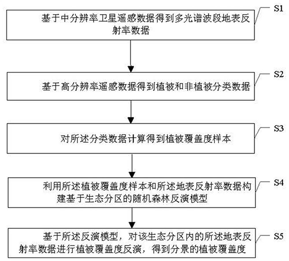
[0010] Such as figure 1 As shown, in step S1, medium-resolution satellite remote sensing data is obtained, atmospheric correction, cloud masking processing, etc. are performed on it, and multi-spectral band surface reflectance data are obtained. Further, the surface albedo data can be resampled.

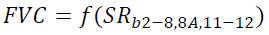
[0011] In one example, Sentinel-2 data can be retrieved from the remote sensing data cloud platform to obtain the surface reflectance of multi-spectral bands (bands 2-8, 8A, 11-12). The 10-meter r


PUM


Abstract

The invention provides a vegetation coverage inversion method based on combination of multi-source remote sensing data and geographical partition data. The method comprises the following steps: obtaining multi-spectral band surface reflectance data based on medium-resolution satellite remote sensing data; obtaining vegetation and non-vegetation classification data based on the high-resolution remote sensing data; calculating the classification data to obtain a vegetation coverage sample; constructing a random forest inversion model based on ecological partition by using the vegetation coverage sample and the surface reflectance data; and based on the inversion model, carrying out vegetation coverage inversion on the surface reflectance data in the ecological partition to obtain the vegetation coverage of the split scene. The invention also correspondingly provides a system. According to the method, the vegetation coverage inversion precision and the data production efficiency can be improved by establishing a model for each ecological partition.

Description


Claims


Application Information

Patent Timeline
Owner CHINESE ACAD OF SURVEYING & MAPPING
Why Eureka
Try Eureka