Real-time lane detection system based on monocular vision and inertial navigation unit

A lane line detection and inertial navigation technology, which is applied in the field of real-time urban multi-lane lane line detection systems, can solve problems such as difficulty in long-term and long-distance stable operation, achieve continuous and smooth local vehicle body positioning, and reduce calculation accumulated errors. , the effect of improving adaptability

Active Publication Date: 2017-12-15
XI AN JIAOTONG UNIV
View PDF3 Cites 0 Cited by
  • Summary
  • Abstract
  • Description
  • Claims
  • Application Information

AI Technical Summary

Problems solved by technology

[0003] The common camera-based lane line detection system, because it only uses image information, cannot solve the missed detection that occurs when the camera cannot collect images containing enough lane information during the process of sudden light changes, obstacles at close range, lane changes, etc. , false detection and other problems, it is difficult to have long-term long-distance stable operation performance, which limits the application possibility of this type of system only in specific environments

Method used


Image

  • Real-time lane detection system based on monocular vision and inertial navigation unit
  • Real-time lane detection system based on monocular vision and inertial navigation unit
  • Real-time lane detection system based on monocular vision and inertial navigation unit

Examples


Example Embodiment

[0032] The present invention will be described in detail below with reference to the drawings.

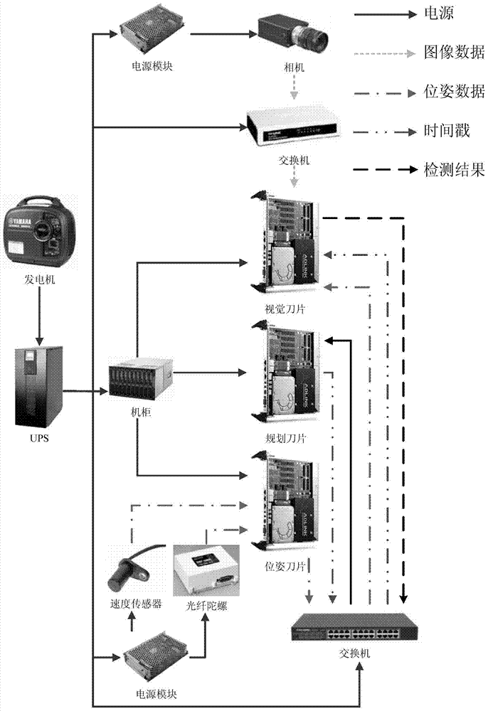
[0033] See figure 1 , The real-time urban multi-lane sensing configuration based on monocular vision and inertial navigation unit and the overall hardware connection diagram installed in the Kuafu No. 1 smart car of Xi’an Jiaotong University are shown in the figure. The system consists of the following types of subsystems: 1. Power system: Yamaha generator provides 220V AC power, which is output from UPS. Except for the sensor itself, which needs to use an additional power module to complete the voltage transformation, other equipment has a supporting independent voltage transformation Equipment; 2. Sensing system: Monocular camera configuration: German Basler digital camera, model: scA640-74gc, lens is Nissan Computar megapixel fixed focal length lens, model: M0814-MP; Inertial navigation unit is configured for vehicle Speed ​​sensor and fiber optic gyroscope DSP3000; 3. Communication s


PUM


Abstract

The invention discloses a real-time lane line detecting system based on monocular vision and an inertial navigation unit. The system mainly comprises an offline calibration and online projection change module, an inertial navigation unit module, a single-frame lane line detecting module and a multi-frame lane line cross-linking checking module based on the inertial navigation unit; the system is capable of accurately detecting multi-lane places of pavements in the urban environment; the lane line detecting system can adapt to different road conditions and road types such as illumination variation, barrier obstruction, large curvature, virtual-actual lines and a plurality of lanes; the system is capable of stably detecting and sensing the lane lines in long distance under a plurality of environments. By adopting a navigation device, an image collecting device and a computing platform which are low in cost and low in power consumption, the system is widely applicable to the fields such as visual navigation of pilotless automobiles and vision-assisted driving of intelligent automobiles.

Description


Claims


Application Information

Patent Timeline
Owner XI AN JIAOTONG UNIV
Why Eureka
Try Eureka